Pre-consultation is free of charge and heavily encouraged prior to making any applications to Hastings County. Please reach out to the respective County Planner via email or phone. Learn more about a pre-consultation here.
Services
PLEASE NOTE: There has been an update to all Planning fees effective June 1, 2025, in accordance with Hastings County Schedule 'A' of By-Law 2025-0008.
Consent Application 2026 FILLABLE FORM
Consent Application Guide 2026
ZBA/MVA Application - Please note that applications for Zoning By-law Amendment and Minor Variance for the Municipality of Marmora and Lake are processed through CloudPermit. Please see their website for more details.
About the Consent Process
The Hastings County Planning and Development Committee serves as the Land Division Committee (“Committee) and is a Committee comprised of Council members. Committee meetings are generally held at the Hastings County Administration Building on the third Tuesday of each month. The duties and responsibilities of the Committee are outlined in the provincial Planning Act.
The Committee grants consents. Generally speaking the “consent” of the Committee enables certain transactions to occur relating to the subdivision of land. These transactions can include the creation of a new lot; leases over 21 (twenty one) years; rights-of-way and easements over 21 (twenty one) years; lot adjustments and extensions; correction to deeds or property descriptions; mortgage or partial discharge of a mortgage; and, foreclosure or exercise of power of sale.
In addition to the previous requirements, it is important to realize that conformity with the County’s Official Plan and Zoning By-law does not mean that the Application for Consent will be automatically approved. Under the Planning Act, the Committee must also have regard to the health, safety, convenience and welfare of the present and future inhabitants of the municipality. As per section 53 of the Planning Act, the Committee must consider the following:
a. Whether a Plan of Subdivision is necessary for the proper and orderly development of the Municipality;
b. The effect of the proposal on matters of provincial interest as referred to in section 2 of the Planning Act;
c. Whether the proposal is premature or in the public interest;
d. Whether the proposal conforms to the Official Plan and adjacent Plans of Subdivision, if any;
e. The suitability of the land for the purposes for which the consent applies;
f. The number, width, location, grades and adequacy of roads adjacent to, and in the vicinity of the lands subject to the consent;
g. The dimensions and shape of the proposed lot(s);
h. The restrictions or proposed restrictions, if any, on the land proposed to be subdivided or on the buildings and structures proposed to be erected thereon and the restrictions, if any, on adjoining lands;
i. Conservation of natural resources and flood control;
j. The adequacy of utilities and municipal services;
k. The adequacy of school sites;
l. The area of land, if any, within the proposal that, exclusive of highways, is to be conveyed or dedicated for public purposes, and;
m. The physical layout of the lots having regard to energy conservation.
To ensure the above factors have been taken into account, the Committee, as part of its Decision, may impose conditions as it considers appropriate.
The Consent Process
Step 1 - Pre-Consultation
View our Pre-Consultation page here to learn more.
The most important step in the process is pre-consultation with a Planner from the County of Hastings Planning and Development Department.
The purpose of pre-consultation is to provide you with an overview of the consent process and to assist you with any initial questions you may have regarding that process. The pre-consultation allows the Planner to determine if there are any major concerns or issues with your proposal with regard to Federal, Provincial or Municipal policies and regulations. The Planner may also be able to identify whether additional information or studies will be required. Pre-consultation helps to avoid unnecessary delays and any “surprises/issues” that may arise later on in the process.
It is also important to consult with your local Municipality as they often provide comments and request conditions of consent approval. There are a variety of other agencies that you may also need to pre-consult with as they may have an interest in or may provide comments on your proposed severance. These agencies may include: the local Conservation Authority, Ministry of Transportation or Ministry of Natural Resources. The County of Hastings Planning Staff can assist you as to which agencies should be consulted prior to submitting an application.
To aid in the Pre-Consultation, the following information should be provided to the Planner:
a. A proposed consent layout sketch showing all structures on the property, adjoining land uses and roads/streets;
b. Legal description, civic address and roll number(s) of the property;
c. Brief description of the proposal;
d. Identification of all other departments and agencies that have been consulted.
Here you will find our Pre-Consultation Form that can be filled out and used when working with one of our planners.
Step 2 - Submitting a Complete Application
Application forms and instructions are available at your local municipal office, at the County of Hastings Planning and Development Office and on the County of Hastings website at www.hastingscounty.com.
The application form MUST be completed in its entirety. Should you have any questions regarding the information required in the application form, please contact the Planning and Development Office. Once completed, the Declaration of the Owner/Agent must be signed before a Commissioner of Oaths to affirm the accuracy of the application form. If an Agent is submitting the application on behalf of the property Owner, the Owner(s) must complete and sign the Owner Acknowledgement and Consent and the Appointment of Authorized Agent section of the application.
An application must include 2 copies of a sketch to scale (preferably prepared by an Ontario Land Surveyor) in accordance with the sketch guidelines on Appendix ‘A’. An application should also include any additional information that you may wish to provide or believe will be helpful in reviewing your application; it should also include information identified during the pre-consultation stage by planning staff or other agencies.
Your application will be reviewed for completeness by planning staff. Any missing or incomplete information may result in a delay of the process and/or your application form being returned to you. Once an application has been deemed complete, planning staff will initiate the consent process.
Fees are payable based on the fee schedule in effect on the date the application is made.
Step 3 - The Consent Process
The Consent process is governed by the policies and regulations of the Planning Act. It may take three (3) to four (4) months from the time of submission of the Application for Consent until the time a Notice of Decision is received. Should there be appeals received, the process may be delayed. Times may vary greatly depending on the number and complexity of issues arising as part of the application review process and/or staff work volumes.
A. Circulation/Notice
The Planning Act requires that when a complete application for consent is received, notice of the application must be sent to a variety of different agencies (e.g. member municipality) for review and comment. Also, notice of the application will be sent to all land owners within 60 metres of the subject property (severed and retained lands). Should any objection be received from an adjoining landowner, a public hearing will then be held.
You will be sent orange placards to be posted at the road side at the two front corners of the severed lands. These placards must be clearly visible from the road and are to remain there until the Land Division/Planning Committee’s decision becomes final.
The placards can be attached to an existing feature such as a fence or pole or placed on a stake.
It is a requirement that you take photos of the placards from the roadside and attach these photos to the Declaration confirming the date that they were posted. This Declaration with attached photos must be returned to the Land Division Secretary. The Commissioner of Oaths portion of the Declaration form may be completed on-site, by appointment, at the closest Municipal office or by a Notary Public of your choice. Photos and the Declaration may be brought in person to the Planning and Development Office located at 235 Pinnacle Street, Belleville, via mail to the attention of the Land Division Secretary, or by email to [email protected].
If the identification placards are lost or damaged/destroyed, please contact the Planning and Development Department immediately to request replacement placards. Failure to post these placards may result in a delay of your application. The placards must be posted a minimum of 14- days prior to a decision being rendered.
After the appeal period for an application has concluded and a Notice of No Appeal has been issued to relevant departments and the Applicant, the placards may then be removed.
• Land Division/Planning Committee
A public meeting is held for those files that are not recommended for approval by County Planning Staff, or those that have been the subject of agency or public concern. Should an objection from an adjoining land owner and/or agency be received, your application will be scheduled for the next available Land Division/Planning Committee meeting. At the public meeting, the Committee will review all of the information and make a decision to Approve, subject to conditions, Deny or Defer the application.
Council of the County of Hastings have delegated authority to the Director of Planning and Development to give provisional consent to uncontested applications. Planning staff prepare a report for the consideration of the Director of Planning and Development which addresses the proposed application with regard to consistency with the Provincial Policy Statement, conformity to the County of Hastings’ Official Plan, compliance with the local municipality’s comprehensive zoning by-law and other applicable legislation. The staff report provides a recommendation and conditions of draft approval which the Director of Planning and Development will consider when reviewing the application and making their final decision. Should planning staff recommend approval, and no concerns or objections received from adjoining land owners or agencies; then your file may be approved without a public hearing by the Director of Planning and Development.
After a decision has been made to approve or deny an application, the Land Division Secretary circulates a notice of decision within 15 days of the date of the decision which includes the conditions that need to be fulfilled. There is a 20 day appeal period (from the date the notice of decision is mailed) which the applicant or any other person or public body that provided written or oral comments prior to the decision being made may appeal the decision or condition(s) to the Local Planning Appeal Tribunal. Should no appeals be received within the 20 day appeal period, the decision is deemed final.
Step 4 - Fulfilling Conditions
The applicant has two (2) years from the date of the mailing of the notice of decision to fulfill all conditions. It is the sole responsibility of the applicant to obtain the necessary approvals or information to fulfill all conditions of approval. If all conditions have not been fulfilled within the specified one year, the approval of the severance will lapse and the applicant will need to reapply for consent and go through the process again.
The applicant should begin to address and fulfill conditions as soon as possible as some conditions take substantial time to complete. There is no extension to the two-year limitation as it is a statutory timeframe and, save and except the passing of emergency provincial legislation, cannot be granted for any reason.
The Committee, or the Director, as the case may be, may impose such reasonable conditions to the provisional approval of an Application for Consent, as it deems appropriate. Such conditions may include, but are not limited to, the following:
1. Proof of Potable Water
Prior to the endorsing of deeds for the severed lot, proof be lodged with the Land Division Office that there is a minimum of three and one-half (3½) gallons per minute of potable water available on the severed lot. This is applied to proposed lots (severed or retained) less than 5 acres in area where no municipal water supply is available.
2. Rezoning
The severed lot be rezoned to “Rural Residential”, for example, and proof of completion and approval of same be lodged with the Land Division Office prior to the endorsing of deeds for the severed lot. (See your individual Municipality for the rezoning procedure).
3. Road Widening
Sufficient land be deeded to the Township for road widening, by REGISTERED deed to provide a road width of 33 feet to the centre line of a Township road, across the frontage of the severed and retained land
4. Cash-In-Lieu of Parkland
A cheque in the amount of $_________ (determined by Municipality) under Section 51.1(3) of the Planning Act, 1990, and upon receipt of same, confirmation be lodged with the Land Division Office.
Fees:
Pursuant to Hastings County Schedule 'A' of By-Law 2025-0008, as amended, the fee for processing an Application for Consent is $1,200.00/application and is payable to the “COUNTY OF HASTINGS” by cheque, certified cheque or money order upon submission of the application for consent. Cash, Debit and Credit Cards cannot be accepted. Application fees are non-refundable.
At the discretion of the Municipality, there may be need for a peer review of any of the required supporting studies/reports, the peer review shall be at the Applicant’s expense.
Should the subject property lie within a Conservation Authority watershed, your Application may be sent to that Conservation Authority for their review. Any fees for this review are invoiced directly by the individual Conservation Authority, and will be your responsibility to provide prompt payment as per their direction.
We strongly encourage all applicants to pre-consult with Planning staff prior to submitting an application.
Application Form:
Each application must be filled out completely and must be accompanied with a sketch of the Subject Lands (this includes both the proposed severed and retained lot). If you are using an agent, please ensure Section 15 has been completed. Incomplete applications may impede the processing of your application or result in your application being returned. Should you have any questions or concerns with regard to any part of the application form please contact the Hastings County Planning and Development Department.
Application Sketch:
The application sketch constitutes part of the complete application.
The sketch must be to scale and preferably prepared by an Ontario Land Surveyor. At least one copy of the sketch should be signed by the owner or agent. If the sketch is not accurate or does not contain the proper details, the processing of the application may be impeded or result in the application being returned to you, due to lack of information. Applications will not be accepted if any of the sketch guidelines are not included on the submitted sketch. Please refer to Appendix ‘A’
APPENDIX ‘A’
Sketch Guidelines
The application must be accompanied by 5 copies of a sketch showing:
1. A scale and north arrow;
2. All abutting lands owned by the owner (if any) and their boundaries and dimensions;
3. The distance between the owner’s lands and the nearest lot line or appropriate landmark (e.g. bridge, railway crossing);
4. The subject land, the part that is to be severed and the part that is to be retained showing the boundaries and dimensions of each. In preparing the sketch, the following colour scheme shall be used for identification:
GREEN OUTLINE – Subject Lands (severed and retained)
RED OUTLINE – Severed Lands
YELLOW OUTLINE – Easements or rights-of-way
BLUE OUTLINE – Benefiting land (when it is a lot addition)
• The location of all lands previously severed, and their file number if known;
• The approximate location, size and type of all existing and proposed buildings and features on the subject lands (e.g. Buildings, railways, highways, wells, septic tanks/fields etc.), and the location of any of these features on adjacent lands which might affect this application. Please indicate the distance of the building/structure from the front, rear and side lot lines;
• The approximate location, size and type of all natural features on the subject lands (e.g. watercourses, drainage ditches, banks, escarpments, ridges, wetlands and wooded areas) and the location of any of these features on adjacent lands which might affect this application.
• The location, width and names of all road allowances, rights-of-way, streets or highways within or abutting the property, indicating whether they are public travelled roads, private roads, rights- of-way or unopened road allowances or shore road allowances. Where access is by water, the location of parking and boat docking facilities;
• The existing uses of adjoining land (e.g. residential, agricultural, extractive, commercial, etc.)
• The location and nature of any restrictive covenant, right of way or easement affecting the subject lands;
• The location of all barns, livestock operations and manure storage areas within 1000 metres of the proposed lot.
APPENDIX ‘B’
Sample Sketch
Creation of a New Lot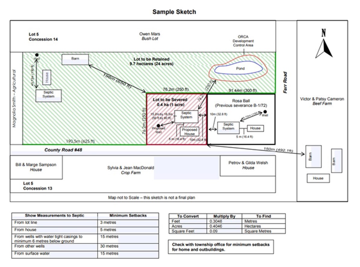
All copies of the sketch or survey must be coloured – red for severed lots, green for retained, yellow for easements or rights-of-ways, and orange for benefiting lot (when it is a lot addition).
The Hastings County Planning Advisory and Land Division Committee serves as the Land Division Committee (“Committee”) and is a committee that is composed of County Council members. Committee meetings are generally held at the Hastings County Administration Building and virtually on the third Tuesday of each month. The duties and responsibilities of the Committee are established by the provincial Planning Act.
The Committee or delegated staff grants consents. Generally speaking, the consent of the Committee enables certain transactions to occur relating to the subdivision of land. These transactions can include:
- The creation of a new lot
- Leases over twenty-five years
- Rights of way and easements over twenty-one years
- Lot adjustments and extensions
- Correction to property descriptions
- Mortgage or partial discharge of a mortgage
- Foreclosure or exercise of power of sale
Before completing a Formal Application, please complete the request for pre-consultation through the County’s Cloudpermit platform. You will be required to register an account in Cloudpermit to access this service. The account is free and can be registered by clicking on the following link:
Cloudpermit
It is important to provide as much detail as you can including: the number and size of proposed lot(s); use of the land (severed and retained); as well as note whether or not there is a barn or barns located on or near the lands (with or without livestock – please indicate which) as all of these details are required for this pre-consultation review keeping in mind that the more details provided at this step, the more realistic response our department can provide. If you should have any questions regarding the process or otherwise, please feel free to utilize this opportunity to include them at this time.
Please complete your submission with a concept sketch of the proposed severance including but not limited to current and proposed structures (if any), current and proposed entrances; and any other identifiable markers on the lands that will be of assistance in the review of your proposal with approximate measurements. If you have plans for future severances, please also advise of these plans. The plans can be uploaded with your pre-consultation in Cloudpermit.
Your pre-consultation will be processed and assigned to one of the Planners of staff who will be in contact with you.
If you have any questions regarding creating an account or submitting information in Cloudpermit please email your question to one of the following Planners, depending on your location:
Emily Galloway - Marmora and Lake, Faraday, & Wollaston
Email: [email protected]
Gib Garrett - Tweed, Deseronto, Carlow Mayo, & Hastings Highlands
Email: [email protected]
Katherine Van Beek - Tyendinaga, Stirling-Rawdon, & Bancroft
Email: [email protected]
Hannah Praisley - Centre Hastings, Tudor and Cashel, Madoc, & Limerick
Madoc office – 56 Russel St
613.473.528 x 3501
Email: [email protected]
Consent applications are submitted through the County’s Cloudpermit portal. Submitting a Formal Application for Consent Package: Please note that should you wish to proceed with submitting your consent for severance application, it is imperative that you discuss this application with the lawyer who will be assisting you through this process. As a result of recent changes to the Planning Act (which governs the division of land in Ontario), it is your responsibility to determine if you wish to have the retained lands transfer/deed stamped. The request must be submitted with your complete application together with your solicitor’s written opinion, as per s. 14.2 of O. Reg. 786/21. Therefore, a complete application submission would include the following:
- Application, including commissioning as required
- Fee, as per Schedule A of the Fees and Charges By-Law 2017-0027
- Required studies, as applicable
- Parcel register(s) for the subject property and for the benefiting property (if a lot addition)
- Solicitor's opinion RE: s. 14.2 of O. Reg. 786/21, as applicable
- Sketch, clearly outlining proposal details as per sketch requirements
- Requirements as per s. 53(1)(1.1) of the Planning Act and s. 18.1 of O.Reg. 197/96, if applicant is a purchaser
Guiding Documents for Development Applications: County of Hastings Official Plan (2018) was adopted by Hastings County Council on December 19, 2017, and approved by the Ministry of Municipal Affairs and Housing on August 3, 2018.
The Official Plan provides goals, objectives, policies, and procedures to guide the sustainable growth and development of our communities that comprise Hastings County. The Official Plan focuses on the things that matter for creating a healthy and vibrant place for us to live: the social, economic, and environmental pillars of our communities. The Official Plan guides growth and physical change in the County, implements infrastructure improvements, protects and enhances natural resources, and conserves cultural heritage resources. The policies and objectives of the Official Plan help shape the future of Hastings County, which is important to all of us who live, work or play here.
County of Hastings Official Plan (2018)
The new County of Hastings Official Plan (2018) was adopted by Hastings County Council on December 19, 2017 and approved by the Ministry of Municipal Affairs on August 3, 2018 with 35 modifications and is now in full force and effect.
The Hastings County Official Plan is comprised of three parts; Part A – Official Plan (main document), Part B the Urban Communities Secondary Plan and Part C -the Bird’s Creek Secondary Plan.
PART A – The Official Plan – The main document that provides policies for the entire County Planning Area. This includes three Schedules;
Schedule A – Land Use Schedule
Central
North
South
Schedule B – Natural Heritage Features and Areas and,
Central
North
South
Schedule C – Aggregate and Mineral Resources
Central
North
South
PART B – The Urban Communities Secondary Plan – A more detailed plan for the six (6) Urban communities including Bancroft Urban Area, Deseronto Urban Area, Madoc Urban Area, Marmora Urban Area, Stirling Urban Area and Tweed Urban Area.
Urban Communities Secondary Plan
PART C – Bird’s Creek Secondary Plan – Similar to the Urban Communities Secondary Plans. Part C provides a detailed land use framework for the hamlet of Birds Creek
Consent Application Notices
- B43_26 - Davidson 0 Centre Line Rd MARMORA- Notice of Application
- B36_26 - McEwen 0 Station Rd MARMORA Notice of Application
- B34_26 Bosnjak_Urbach Lake WOLLASTON_Notice of Application
- B29_26 Neill.Smith 1026 Twin Sister Lakes Rd MARMORA Notice of Application
- B13_26 Lowes 54 Dog Bay Rd HERSCHEL Notice of Application
- B12_26 Rowden O-At-Ka Rd HERSCHEL Notice of Application
- B26.27.28_26 Neill.Smith 1026 Twin Sister Lakes Rd MARMORA Notice of Application
- B24_26 Fulton.Clarke 73 Livingstone Ave E CENTRE HASTINGS Notice of Application
- B11_26 Neil_33 Card Rd _HASTINGS HIGHLANDS - Notice of Application
- B10_26 Neil_33 Card Rd _HASTINGS HIGHLANDS - Notice of Application
- B9_26 Card_0 Card Rd_ HASTINGS HIGHLANDS - Notice of Application
- B8_26 Card_ 0 Card Rd_ HASTINGS HIGHLANDS - Notice of Application
Subdivision Application Notices
Public Meeting Notices
- D14-05-2026 CH - 9948 Hwy 62 - Zechel - Notice of Public Meeting for Zoning By-Law Amendment
- D14-03-2026 TW - 103 Brinson Rd, Tweed - Preston - Notice of Public Meeting for Zoning Amendment
- D14-04-2026 TW - 1543 Crookston Rd, Tweed - Palmateer - Notice of Public Meeting for Zoning Amendment
- D14-06-2026 M&L - Bursthall St, Marmora - Habitat for Humanity - Notice of Public Meeting for Zoning Amendment
- D14-05-2026 M&L -783 Station Rd, Marmora - Szukala - Notice of Public Meeting for Zoning Amendment
- D14-01-2026 WOLL - 230 and 238 Chescher Lane, Wollaston - Tapsell - Notice of Public Meeting for Zoning By-Law Amendment
- D14-05-2026 TY - 1149 Read Road - Durkin Notice of Public Meeting for Zoning Amendment
- D14-04-2026 TY - East of 645 Marysville Rd - McRae Notice of Public Meeting for Zoning Amendment
- D14-06-2026 - TY - 1906 Casey Road - Sherman Notice of Public Meeting for Zoning Amendment
- D14-04-2026 - MADO - 562 Pigden Rd, Madoc - Bak - Notice of Public Meeting for Zoning By-law Amendment
- D14-03-2026 - MADO - 997-113 Hunt Club Rd, Madoc - Polmateer - Notice of Public Meeting for Zoning By-law Amendment
- D14-05-2026 TW - 477 Allore Rd, Tweed - Massey & Allore - Package for Notice of Public Meeting for Zoning By-Law Amendment
Reports
Key Contacts

Jason Budd
Senior Planner


Gib Garrett
Planner